Gmunden night lights from space
Night Light of Gmunden (Upper Austria) from space (Austria) Src. Average luminocity for 10x10km area is 5.544% and for 50x50km: 1.5366%.
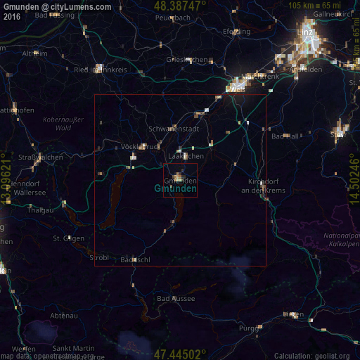
Analysis of Gmunden night lights 2016
Square area 10x10 km:
 0%
0%90-99
0.14%80-89
0.99%70-79
1.14%60-69
1.14%50-59
1.14%40-49
0%30-39
1.14%20-29
2.13%10-19
0.71%0-9
91.48%Square area 50x50 km:
0.13%90-99
0.18%80-89
0.15%70-79
0.09%60-69
0.19%50-59
0.39%40-49
0.25%30-39
0.27%20-29
0.27%10-19
0.75%0-9
97.32%Clear (daylight) street map image can be seen on geolist.org.
Map coordinates:
48° 23' 14.9" North, 13° 5' 46.4" East
47° 55' 6.2" North, 13° 47' 57.6" East
47° 26' 42.1" North, 14° 30' 8.9" East
Some cities around Gmunden sort by population:
• Wels
32.6 km =20.3 mi,  32°
32°
• Laakirchen
7.3 km =4.5 mi,  13°
13°
• Attnang-Puchheim
11.7 km =7.3 mi,  328°
328°
• Vorchdorf
13.1 km =8.1 mi,  43°
43°
• Kremsmünster
28.7 km =17.8 mi,  58°
58°
• Lichtenegg
29.8 km =18.5 mi, 30°
• Micheldorf in Oberösterreich
25.3 km =15.7 mi,  100°
100°
• Wimpassing
30.8 km =19.1 mi, 26°
2778436 (p: 13,191)
Sources (retrieved 2019-11-25):
» Earth at Night: Flat Maps 2012, 2016