Micheldorf in Oberösterreich night lights from space
Night Light of Micheldorf in Oberösterreich (Upper Austria) from space (Austria) Src. Average luminocity for 10x10km area is 3.1477% and for 50x50km: 1.4123%.
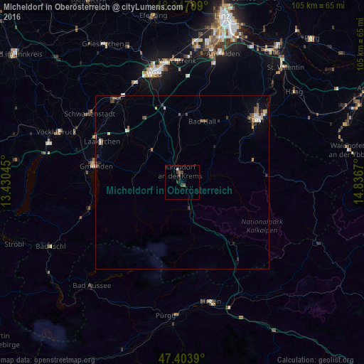
Analysis of Micheldorf in Oberösterreich night lights 2016
Square area 10x10 km:
 0.28%
0.28%90-99
0.28%80-89
0%70-79
0%60-69
0.43%50-59
1.28%40-49
0.85%30-39
1.28%20-29
1.28%10-19
0.57%0-9
93.75%Square area 50x50 km:
0.15%90-99
0.16%80-89
0.18%70-79
0.1%60-69
0.13%50-59
0.37%40-49
0.25%30-39
0.31%20-29
0.26%10-19
0.34%0-9
97.75%Clear (daylight) street map image can be seen on geolist.org.
Map coordinates:
48° 20' 49.5" North, 13° 25' 49.6" East
47° 52' 39.5" North, 14° 8' 0.9" East
47° 24' 14" North, 14° 50' 12.1" East
Some cities around Micheldorf in Oberösterreich sort by population:
• Steyr
28.2 km =17.5 mi,  49°
49°
• Gmunden
25.3 km =15.7 mi,  280°
280°
• Laakirchen
26 km =16.2 mi,  296°
296°
• Vorchdorf
21.1 km =13.1 mi,  311°
311°
• Kremsmünster
19.5 km =12.1 mi,  359°
359°
• Neuhofen an der Krems
29.9 km =18.6 mi,  13°
13°
• Neuzeug
24.3 km =15.1 mi,  37°
37°
• Bad Hall
18.7 km =11.6 mi,  17°
17°
2771619 (p: 5,854)
Sources (retrieved 2019-11-25):
» Earth at Night: Flat Maps 2012, 2016