Bruck an der Leitha night lights from space
Night Light of Bruck an der Leitha (Lower Austria) from space (Austria) Src. Average luminocity for 10x10km area is 11.4063% and for 50x50km: 13.0583%.
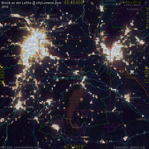
Analysis of Bruck an der Leitha night lights 2016
Square area 10x10 km:
 0.85%
0.85%90-99
2.27%80-89
0.71%70-79
2.13%60-69
0.57%50-59
0.43%40-49
1.28%30-39
2.56%20-29
0.14%10-19
7.39%0-9
81.68%Square area 50x50 km:
2.22%90-99
2.54%80-89
1.17%70-79
1.34%60-69
1.65%50-59
1.51%40-49
1.31%30-39
2.08%20-29
3.52%10-19
6.59%0-9
76.06%Clear (daylight) street map image can be seen on geolist.org.
Map coordinates:
48° 29' 5.5" North, 16° 3' 48.8" East
48° 1' 0" North, 16° 46' 0" East
47° 32' 39.1" North, 17° 28' 11.3" East
Some cities around Bruck an der Leitha sort by population:
• Bratislava, SK
29.2 km =18.1 mi,  59°
59°
• Schwechat
25.8 km =16 mi,  300°
300°
• Eisenstadt
26.3 km =16.3 mi,  223°
223°
• Neusiedl am See
9.4 km =5.8 mi,  143°
143°
• Groß-Enzersdorf
26.2 km =16.3 mi,  322°
322°
• Hainburg an der Donau
19.6 km =12.2 mi,  42°
42°
• Himberg
25.9 km =16.1 mi,  286°
286°
• Ebreichsdorf
27.6 km =17.1 mi,  255°
255°
2781373 (p: 6,882)
Sources (retrieved 2019-11-25):
» Earth at Night: Flat Maps 2012, 2016