Eisenstadt night lights from space
Night Light of Eisenstadt (Burgenland) from space (Austria) Src. Average luminocity for 10x10km area is 20.0372% and for 50x50km: 11.6168%.
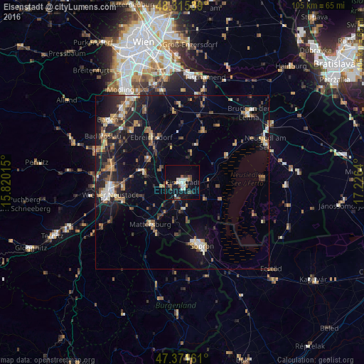
Analysis of Eisenstadt night lights 2016
Square area 10x10 km:
 2.68%
2.68%90-99
4.76%80-89
1.04%70-79
1.93%60-69
1.34%50-59
2.53%40-49
3.13%30-39
1.34%20-29
1.19%10-19
24.55%0-9
55.51%Square area 50x50 km:
0.88%90-99
1.44%80-89
1.08%70-79
1.72%60-69
1.64%50-59
1.66%40-49
1.78%30-39
1.86%20-29
3.5%10-19
9.37%0-9
75.07%Clear (daylight) street map image can be seen on geolist.org.
Map coordinates:
48° 18' 55.4" North, 15° 49' 12.5" East
47° 50' 44.3" North, 16° 31' 23.8" East
47° 22' 17.8" North, 17° 13' 35" East
Some cities around Eisenstadt sort by population:
• Sopron, HU
18.6 km =11.6 mi,  164°
164°
• Wiener Neustadt
22.2 km =13.8 mi,  258°
258°
• Kottingbrunn
25 km =15.5 mi,  297°
297°
• Bruck an der Leitha
26.3 km =16.3 mi,  43°
43°
• Traiskirchen
25.4 km =15.8 mi,  317°
317°
• Mattersburg
15.5 km =9.6 mi,  216°
216°
• Ebreichsdorf
15 km =9.3 mi, 324°
• Sollenau
21.3 km =13.2 mi,  285°
285°
2780190 (p: 9,217)
Sources (retrieved 2019-11-25):
» Earth at Night: Flat Maps 2012, 2016