Schwechat night lights from space
Night Light of Schwechat (Lower Austria) from space (Austria) Src. Average luminocity for 10x10km area is 63.4821% and for 50x50km: 26.8849%.
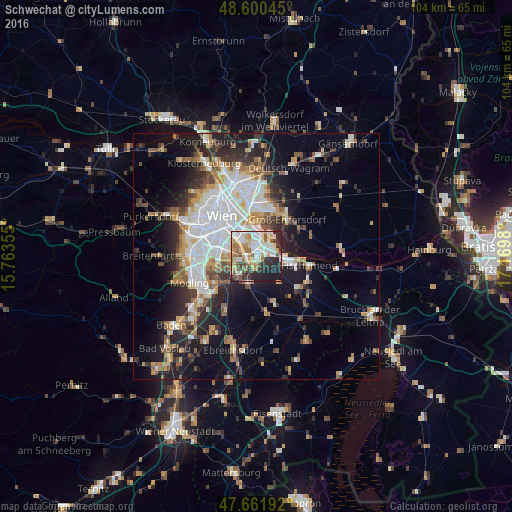
Analysis of Schwechat night lights 2016
Square area 10x10 km:
 13.99%
90-99
16.52%80-89
9.82%70-79
6.85%60-69
11.46%50-59
5.51%40-49
4.32%30-39
7.89%20-29
16.82%10-19
6.85%0-9
0%Square area 50x50 km:
6.4%90-99
5.43%80-89
2.37%70-79
3.06%60-69
3.44%50-59
2.94%40-49
2.64%30-39
3.65%20-29
6.74%10-19
11.42%0-9
51.93%Clear (daylight) street map image can be seen on geolist.org.
Map coordinates:
48° 36' 1.6" North, 15° 45' 48.8" East
48° 7' 60" North, 16° 28' 0" East
47° 39' 42.9" North, 17° 10' 11.3" East
Some cities around Schwechat sort by population:
• Vienna
10.9 km =6.8 mi,  319°
319°
• Favoriten
7 km =4.3 mi,  296°
296°
• Simmering
6.1 km =3.8 mi,  336°
336°
• Meidling
10.6 km =6.6 mi,  290°
290°
• Vösendorf
9.5 km =5.9 mi,  261°
261°
• Groß-Enzersdorf
9.9 km =6.2 mi,  38°
38°
• Himberg
6.1 km =3.8 mi,  204°
204°
• Leopoldsdorf
5.9 km =3.7 mi,  250°
250°
2765388 (p: 12,351)
Sources (retrieved 2019-11-25):
» Earth at Night: Flat Maps 2012, 2016