Villa Berthet night lights from space
Night Light of Villa Berthet (Chaco) from space (Argentina) Src. Average luminocity for 10x10km area is 9.4394% and for 50x50km: 0.7413%.
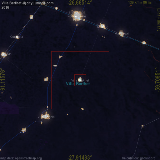
Analysis of Villa Berthet night lights 2016
Square area 10x10 km:
 1.33%
1.33%90-99
1.7%80-89
0.95%70-79
2.08%60-69
0.76%50-59
0.76%40-49
1.52%30-39
0.76%20-29
0.76%10-19
0.76%0-9
88.64%Square area 50x50 km:
0.08%90-99
0.1%80-89
0.08%70-79
0.19%60-69
0.11%50-59
0.06%40-49
0.11%30-39
0.04%20-29
0.1%10-19
0.1%0-9
99.03%Clear (daylight) street map image can be seen on geolist.org.
Map coordinates:
26° 39' 54.5" South, 61° 6' 56.7" West
27° 17' 30.3" South, 60° 24' 45.5" West
27° 54' 53.4" South, 59° 42' 34.2" West
Some cities around Villa Berthet sort by population:
• Presidencia Roque Sáenz Peña
56.4 km =35 mi,  357°
357°
• Quitilipi
50.8 km =31.6 mi,  22°
22°
• Machagai
54.3 km =33.7 mi,  41°
41°
• Presidencia de la Plaza
65 km =40.4 mi,  60°
60°
• San Bernardo
29.6 km =18.4 mi,  270°
270°
• Campo Largo
69.2 km =43 mi,  322°
322°
• Corzuela
66.7 km =41.4 mi,  304°
304°
• Coronel Du Graty
65.7 km =40.8 mi,  228°
228°
3832797 (p: 12,029)
Sources (retrieved 2019-11-25):
» Earth at Night: Flat Maps 2012, 2016