Puerto Vilelas night lights from space
Night Light of Puerto Vilelas (Chaco) from space (Argentina) Src. Average luminocity for 10x10km area is 53.8532% and for 50x50km: 16.8592%.
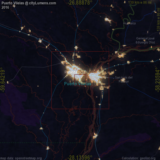
Analysis of Puerto Vilelas night lights 2016
Square area 10x10 km:
 14.88%
90-99
10.52%80-89
5.36%70-79
3.97%60-69
5.75%50-59
5.56%40-49
14.88%30-39
7.74%20-29
10.71%10-19
17.66%0-9
2.98%Square area 50x50 km:
3.67%90-99
2.18%80-89
1.8%70-79
2.41%60-69
2.24%50-59
1.5%40-49
3.5%30-39
2.68%20-29
4.7%10-19
8.5%0-9
66.82%Clear (daylight) street map image can be seen on geolist.org.
Map coordinates:
26° 53' 19.6" South, 59° 38' 31.9" West
27° 30' 50.9" South, 58° 56' 20.6" West
28° 8' 9.5" South, 58° 14' 9.4" West
Some cities around Puerto Vilelas sort by population:
• Resistencia
7.4 km =4.6 mi,  323°
323°
• Corrientes
11.5 km =7.1 mi,  63°
63°
• Barranqueras
3.6 km =2.2 mi,  359°
359°
• Fontana
13.6 km =8.5 mi, 321°
• San Luis del Palmar
37.9 km =23.5 mi,  88°
88°
• La Leonesa
57.8 km =35.9 mi,  23°
23°
• Paso de la Patria
42.4 km =26.3 mi, 58°
• Margarita Belén
28.3 km =17.6 mi,  353°
353°
3429713 (p: 8,455)
Sources (retrieved 2019-11-25):
» Earth at Night: Flat Maps 2012, 2016