La Punta night lights from space
Night Light of La Punta (San Luis) from space (Argentina) Src. Average luminocity for 10x10km area is 31.5664% and for 50x50km: 10.6184%.
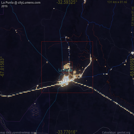
Analysis of La Punta night lights 2016
Square area 10x10 km:
 0%
0%90-99
0.35%80-89
6.64%70-79
9.97%60-69
9.79%50-59
1.75%40-49
0.87%30-39
2.97%20-29
14.34%10-19
35.84%0-9
17.48%Square area 50x50 km:
1.26%90-99
1.05%80-89
2.44%70-79
1.84%60-69
1.37%50-59
0.57%40-49
1.2%30-39
1.43%20-29
3.49%10-19
6.06%0-9
79.28%Clear (daylight) street map image can be seen on geolist.org.
Map coordinates:
32° 35' 35.7" South, 67° 0' 57" West
33° 11' 1.2" South, 66° 18' 45.7" West
33° 46' 12.6" South, 65° 36' 34.5" West
Some cities around La Punta sort by population:
• San Luis
12.6 km =7.8 mi,  189°
189°
• Villa Mercedes
96.4 km =59.9 mi,  124°
124°
• Merlo
153.2 km =95.2 mi,  52°
52°
• Justo Daract
128.9 km =80.1 mi,  125°
125°
• Coronel Moldes
166.6 km =103.5 mi,  107°
107°
• Sampacho
149.5 km =92.9 mi,  98°
98°
• La Toma
65.8 km =40.9 mi,  77°
77°
• Tilisarao
107.7 km =66.9 mi,  62°
62°
7284819 (p: 15,000)
Sources (retrieved 2019-11-25):
» Earth at Night: Flat Maps 2012, 2016