Crespo night lights from space
Night Light of Crespo (Entre Rios) from space (Argentina) Src. Average luminocity for 10x10km area is 23.799% and for 50x50km: 3.5787%.
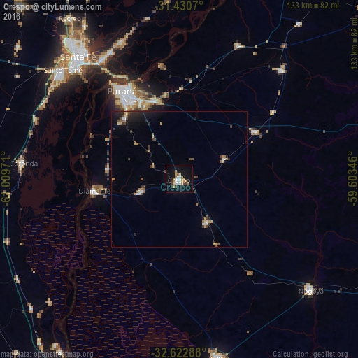
Analysis of Crespo night lights 2016
Square area 10x10 km:
 4.2%
4.2%90-99
3.5%80-89
1.4%70-79
5.59%60-69
3.5%50-59
1.4%40-49
0.52%30-39
3.5%20-29
0.52%10-19
25.35%0-9
50.52%Square area 50x50 km:
0.34%90-99
0.34%80-89
0.3%70-79
0.57%60-69
0.48%50-59
0.41%40-49
0.41%30-39
0.69%20-29
0.76%10-19
2.63%0-9
93.08%Clear (daylight) street map image can be seen on geolist.org.
Map coordinates:
31° 25' 50.5" South, 61° 0' 35" West
32° 1' 43.4" South, 60° 18' 23.7" West
32° 37' 22.4" South, 59° 36' 12.5" West
Some cities around Crespo sort by population:
• Santa Fe
56.8 km =35.3 mi,  318°
318°
• Paraná
39 km =24.2 mi,  327°
327°
• Diamante
31.5 km =19.6 mi,  262°
262°
• Coronda
58.2 km =36.2 mi,  276°
276°
• Viale
33.4 km =20.8 mi,  57°
57°
• General Ramírez
19.2 km =11.9 mi,  148°
148°
• Villa María Grande
55.6 km =34.5 mi,  43°
43°
• San Benito
30.1 km =18.7 mi, 334°
3859904 (p: 18,296)
Sources (retrieved 2019-11-25):
» Earth at Night: Flat Maps 2012, 2016