Chamical night lights from space
Night Light of Chamical (La Rioja) from space (Argentina) Src. Average luminocity for 10x10km area is 14.0879% and for 50x50km: 0.8792%.
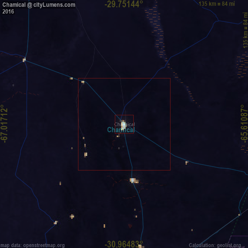
Analysis of Chamical night lights 2016
Square area 10x10 km:
 3.3%
3.3%90-99
1.1%80-89
3.3%70-79
1.1%60-69
1.47%50-59
1.47%40-49
0%30-39
0.92%20-29
2.38%10-19
1.47%0-9
83.52%Square area 50x50 km:
0.13%90-99
0.04%80-89
0.23%70-79
0.13%60-69
0.09%50-59
0.09%40-49
0.03%30-39
0.13%20-29
0.19%10-19
0.07%0-9
98.87%Clear (daylight) street map image can be seen on geolist.org.
Map coordinates:
29° 45' 5.2" South, 67° 1' 1.6" West
30° 21' 36.1" South, 66° 18' 50.4" West
30° 57' 53.4" South, 65° 36' 39.1" West
Some cities around Chamical sort by population:
• La Rioja
117.5 km =73 mi,  333°
333°
• Chilecito
175.5 km =109.1 mi,  319°
319°
• Cruz del Eje
150.2 km =93.3 mi,  105°
105°
• Recreo
170.2 km =105.8 mi,  45°
45°
• Capilla del Monte
180 km =111.8 mi, 108°
• Villa de Soto
137.3 km =85.3 mi, 113°
• San Agustín de Valle Fértil
114.7 km =71.3 mi,  254°
254°
• Capayán
178.2 km =110.7 mi,  8°
8°
3861824 (p: 13,383)
Sources (retrieved 2019-11-25):
» Earth at Night: Flat Maps 2012, 2016