Masis night lights from space
Night Light of Masis (Ararat) from space (Armenia) Src. Average luminocity for 10x10km area is 10.4497% and for 50x50km: 9.085%.
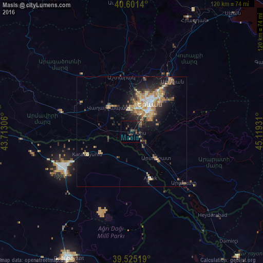
Analysis of Masis night lights 2016
Square area 10x10 km:
 0%
0%90-99
0%80-89
0.65%70-79
0.32%60-69
1.46%50-59
2.11%40-49
5.84%30-39
4.06%20-29
0.97%10-19
11.36%0-9
73.21%Square area 50x50 km:
0.51%90-99
0.94%80-89
1.43%70-79
1.81%60-69
2.28%50-59
0.98%40-49
1.47%30-39
1.5%20-29
2.21%10-19
5.09%0-9
81.77%Clear (daylight) street map image can be seen on geolist.org.
Map coordinates:
40° 36' 5" North, 43° 42' 47" East
40° 3' 55.5" North, 44° 24' 58.2" East
39° 31' 30.7" North, 45° 7' 9.5" East
Some cities around Masis sort by population:
• Yerevan
15.3 km =9.5 mi,  32°
32°
• Vagharshapat
15.2 km =9.4 mi,  317°
317°
• Abovyan
29.6 km =18.4 mi,  38°
38°
• Artashat
15.9 km =9.9 mi,  136°
136°
• Ashtarak
26.4 km =16.4 mi,  349°
349°
• Yeghvard
29.5 km =18.3 mi,  11°
11°
• Metsamor
10.6 km =6.6 mi,  274°
274°
• Garrni
27.7 km =17.2 mi,  77°
77°
616435 (p: 18,911)
Sources (retrieved 2019-11-25):
» Earth at Night: Flat Maps 2012, 2016