Cërrik night lights from space
Night Light of Cërrik (Elbasan) from space (Albania) Src. Average luminocity for 10x10km area is 1.3707% and for 50x50km: 2.2785%.
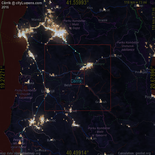
Analysis of Cërrik night lights 2016
Square area 10x10 km:
 0%
0%90-99
0%80-89
0%70-79
0%60-69
0.68%50-59
0%40-49
0%30-39
0%20-29
1.02%10-19
0%0-9
98.3%Square area 50x50 km:
0.17%90-99
0.31%80-89
0.26%70-79
0.41%60-69
0.31%50-59
0.22%40-49
0.36%30-39
0.37%20-29
0.32%10-19
1.28%0-9
95.99%Clear (daylight) street map image can be seen on geolist.org.
Map coordinates:
41° 33' 35.7" North, 19° 16' 21.8" East
41° 1' 54" North, 19° 58' 33" East
40° 29' 56.9" North, 20° 40' 44.3" East
Some cities around Cërrik sort by population:
• Tirana
35.4 km =22 mi,  338°
338°
• Elbasan
12.7 km =7.9 mi,  44°
44°
• Lushnjë
24.8 km =15.4 mi,  246°
246°
• Kuçovë
26.2 km =16.3 mi,  190°
190°
• Librazhd-Qendër
35.3 km =21.9 mi,  58°
58°
• Gramsh
25.1 km =15.6 mi,  135°
135°
• Peqin
18.9 km =11.7 mi,  274°
274°
• Rrogozhinë
26.5 km =16.5 mi,  280°
280°
3185897 (p: 14,269)
Sources (retrieved 2019-11-25):
» Earth at Night: Flat Maps 2012, 2016