Ar Ruways night lights from space
Night Light of Ar Ruways (Abu Dhabi) from space (United Arab Emirates) Src. Average luminocity for 10x10km area is 86.5303% and for 50x50km: 17.8063%.
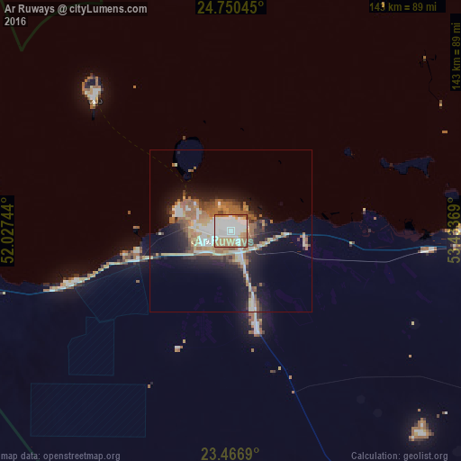
Analysis of Ar Ruways night lights 2016
Square area 10x10 km:
 29.55%
90-99
31.06%80-89
4.92%70-79
9.66%60-69
19.32%50-59
3.03%40-49
2.46%30-39
0%20-29
0%10-19
0%0-9
0%Square area 50x50 km:
2.41%90-99
3.65%80-89
2.05%70-79
1.86%60-69
4%50-59
2.99%40-49
2.03%30-39
1.68%20-29
3.48%10-19
9.72%0-9
66.13%Clear (daylight) street map image can be seen on geolist.org.
Map coordinates:
24° 45' 1.6" North, 52° 1' 38.8" East
24° 6' 37" North, 52° 43' 50" East
23° 28' 0.8" North, 53° 26' 1.3" East
Some cities around Ar Ruways sort by population:
• Abu Dhabi
173.1 km =107.6 mi,  77°
77°
• Doha, QA
178.2 km =110.7 mi,  317°
317°
• Musaffah
179.8 km =111.7 mi, 81°
• Zayed City
111.3 km =69.2 mi,  117°
117°
• Al Wakrah, QA
164 km =101.9 mi, 316°
• Muzayri‘
152.2 km =94.6 mi,  134°
134°
• Musay‘īd, QA
154.5 km =96 mi,  309°
309°
• Al Wukayr, QA
167.2 km =103.9 mi, 313°
292688 (p: 16,000)
Sources (retrieved 2019-11-25):
» Earth at Night: Flat Maps 2012, 2016