Rosebank night lights from space
Night Light of Rosebank (Western Cape) from space (South Africa) Src. Average luminocity for 10x10km area is 90.2343% and for 50x50km: 37.5637%.
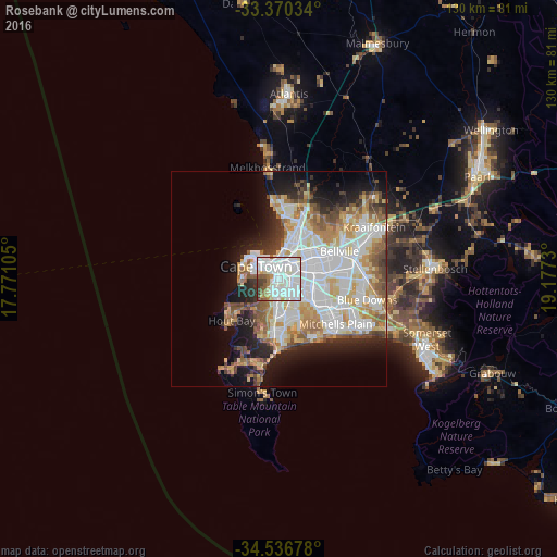
Analysis of Rosebank night lights 2016
Square area 10x10 km:
 45.1%
45.1%90-99
31.29%80-89
5.77%70-79
2.45%60-69
4.55%50-59
5.24%40-49
2.45%30-39
3.15%20-29
0%10-19
0%0-9
0%Square area 50x50 km:
11.37%90-99
8.8%80-89
4.45%70-79
4.52%60-69
3.96%50-59
4.5%40-49
3.03%30-39
2.82%20-29
5.24%10-19
9.54%0-9
41.75%Clear (daylight) street map image can be seen on geolist.org.
Map coordinates:
33° 22' 13.2" South, 17° 46' 15.8" East
33° 57' 20" South, 18° 28' 27" East
34° 32' 12.4" South, 19° 10' 38.3" East
Some cities around Rosebank sort by population:
• Cape Town
5.7 km =3.5 mi,  305°
305°
• Kraaifontein
25.4 km =15.8 mi,  61°
61°
• Retreat
11.1 km =6.9 mi,  179°
179°
• Lansdowne
4.1 km =2.5 mi,  148°
148°
• Rondebosch
0.9 km =0.6 mi,  166°
166°
• Claremont
2.9 km =1.8 mi,  196°
196°
• Constantia
9.9 km =6.2 mi,  211°
211°
• Newlands
3.5 km =2.2 mi,  223°
223°
3362024 (p: 10,000)
Sources (retrieved 2019-11-25):
» Earth at Night: Flat Maps 2012, 2016