Lansdowne night lights from space
Night Light of Lansdowne (Western Cape) from space (South Africa) Src. Average luminocity for 10x10km area is 93.7133% and for 50x50km: 38.8305%.
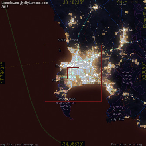
Analysis of Lansdowne night lights 2016
Square area 10x10 km:
 49.48%
90-99
27.45%80-89
8.57%70-79
9.79%60-69
4.72%50-59
0%40-49
0%30-39
0%20-29
0%10-19
0%0-9
0%Square area 50x50 km:
11.44%90-99
8.9%80-89
4.6%70-79
4.76%60-69
4.25%50-59
4.9%40-49
3.42%30-39
3.38%20-29
5.89%10-19
9.09%0-9
39.37%Clear (daylight) street map image can be seen on geolist.org.
Map coordinates:
33° 24' 8.5" South, 17° 47' 39.6" East
33° 59' 14.5" South, 18° 29' 50.9" East
34° 34' 6.1" South, 19° 12' 2.1" East
Some cities around Lansdowne sort by population:
• Cape Town
9.7 km =6 mi,  314°
314°
• Kraaifontein
25.5 km =15.8 mi,  52°
52°
• Retreat
7.8 km =4.8 mi,  194°
194°
• Rondebosch
3.3 km =2.1 mi,  323°
323°
• Claremont
3.1 km =1.9 mi,  284°
284°
• Rosebank
4.1 km =2.5 mi,  328°
328°
• Constantia
8.8 km =5.5 mi,  236°
236°
• Newlands
4.7 km =2.9 mi, 282°
3364682 (p: 17,399)
Sources (retrieved 2019-11-25):
» Earth at Night: Flat Maps 2012, 2016