Hani i Elezit night lights from space
Night Light of Hani i Elezit (Ferizaj) from space (Kosovo) Src. Average luminocity for 10x10km area is 2.2439% and for 50x50km: 10.0353%.
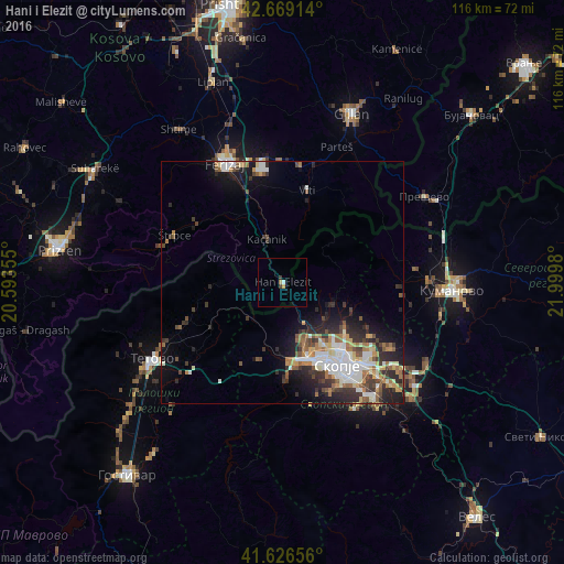
Analysis of Hani i Elezit night lights 2016
Square area 10x10 km:
 0.45%
0.45%90-99
0.15%80-89
0%70-79
0.61%60-69
0.61%50-59
0%40-49
0%30-39
1.06%20-29
0.15%10-19
0%0-9
96.97%Square area 50x50 km:
1.51%90-99
2.11%80-89
0.97%70-79
0.93%60-69
1.61%50-59
1.33%40-49
1.4%30-39
1.78%20-29
3.19%10-19
4.66%0-9
80.5%Clear (daylight) street map image can be seen on geolist.org.
Map coordinates:
42° 40' 8.9" North, 20° 35' 36.8" East
42° 9' 0" North, 21° 17' 48" East
41° 37' 35.6" North, 21° 59' 59.3" East
Some cities around Hani i Elezit sort by population:
• Gjorče Petro, MK
16.5 km =10.3 mi,  163°
163°
• Saraj, MK
16.9 km =10.5 mi,  171°
171°
• Šuto Orizare, MK
16.2 km =10.1 mi,  139°
139°
• Kondovo, MK
15.5 km =9.6 mi, 174°
• Kačanik
9.6 km =6 mi,  341°
341°
• Radishani, MK
15.9 km =9.9 mi,  128°
128°
• Чучер - Сандево, MK
8.7 km =5.4 mi, 126°
• Jegunovce, MK
16.7 km =10.4 mi,  238°
238°
791539 (p: 9,389)
Sources (retrieved 2019-11-25):
» Earth at Night: Flat Maps 2012, 2016