Yazoo City night lights from space
Night Light of Yazoo City (Mississippi) from space (United States) Src. Average luminocity for 10x10km area is 43.528% and for 50x50km: 2.5932%.
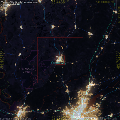
Analysis of Yazoo City night lights 2016
Square area 10x10 km:
 6.12%
6.12%90-99
8.57%80-89
6.64%70-79
6.29%60-69
8.04%50-59
3.67%40-49
4.02%30-39
8.39%20-29
8.39%10-19
33.04%0-9
6.82%Square area 50x50 km:
0.26%90-99
0.36%80-89
0.3%70-79
0.46%60-69
0.44%50-59
0.19%40-49
0.24%30-39
0.46%20-29
0.54%10-19
2.39%0-9
94.36%Clear (daylight) street map image can be seen on geolist.org.
Map coordinates:
33° 26' 37.7" North, 91° 6' 31.6" West
32° 51' 18.5" North, 90° 24' 20.3" West
32° 15' 45" North, 89° 42' 9.1" West
Some cities around Yazoo City sort by population:
• Jackson
65.2 km =40.5 mi,  161°
161°
• Pearl
69.5 km =43.2 mi, 158°
• Madison
51.5 km =32 mi,  148°
148°
• Clinton
57.6 km =35.8 mi,  172°
172°
• Ridgeland
53.9 km =33.5 mi, 151°
• Canton
43.8 km =27.2 mi,  128°
128°
• Indianola
70.2 km =43.6 mi,  340°
340°
• Flowood
65.6 km =40.8 mi, 157°
4451810 (p: 11,245)
Sources (retrieved 2019-11-25):
» Earth at Night: Flat Maps 2012, 2016