Woodlake night lights from space
Night Light of Woodlake (California) from space (United States) Src. Average luminocity for 10x10km area is 5.5752% and for 50x50km: 8.4288%.
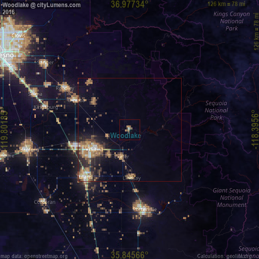
Analysis of Woodlake night lights 2016
Square area 10x10 km:
 0%
0%90-99
0.7%80-89
0%70-79
2.1%60-69
0.7%50-59
2.27%40-49
0.52%30-39
1.4%20-29
0%10-19
0%0-9
92.31%Square area 50x50 km:
0.55%90-99
0.79%80-89
0.66%70-79
1.55%60-69
1.96%50-59
1.86%40-49
1.42%30-39
1.43%20-29
2.74%10-19
3.79%0-9
83.26%Clear (daylight) street map image can be seen on geolist.org.
Map coordinates:
36° 58' 38.4" North, 119° 48' 6.7" West
36° 24' 48.8" North, 119° 5' 55.4" West
35° 50' 44.4" North, 118° 23' 44.2" West
Some cities around Woodlake sort by population:
• Visalia
19.6 km =12.2 mi,  241°
241°
• Tulare
31.9 km =19.8 mi,  224°
224°
• Dinuba
29.5 km =18.3 mi,  299°
299°
• Lindsay
23.4 km =14.5 mi,  177°
177°
• Farmersville
16.1 km =10 mi, 216°
• Exeter
13.6 km =8.5 mi,  196°
196°
• Orange Cove
30.3 km =18.8 mi,  320°
320°
• Orosi
22.3 km =13.9 mi,  310°
310°
5410416 (p: 7,654)
Sources (retrieved 2019-11-25):
» Earth at Night: Flat Maps 2012, 2016