Westchester night lights from space
Night Light of Westchester (Illinois) from space (United States) Src. Average luminocity for 10x10km area is 95.3921% and for 50x50km: 89.1144%.
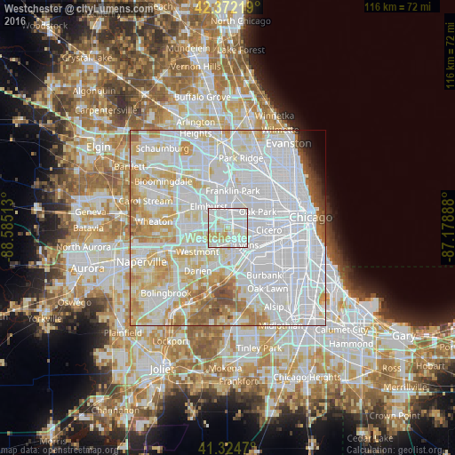
Analysis of Westchester night lights 2016
Square area 10x10 km:
 38.1%
38.1%90-99
44.6%80-89
11.59%70-79
5.71%60-69
0%50-59
0%40-49
0%30-39
0%20-29
0%10-19
0%0-9
0%Square area 50x50 km:
46.32%90-99
22.41%80-89
11.14%70-79
7.84%60-69
4.81%50-59
2.73%40-49
1.33%30-39
0.66%20-29
0.64%10-19
0.82%0-9
1.31%Clear (daylight) street map image can be seen on geolist.org.
Map coordinates:
42° 22' 19.9" North, 88° 35' 6.5" West
41° 51' 2.1" North, 87° 52' 55.2" West
41° 19' 28.9" North, 87° 10' 44" West
Some cities around Westchester sort by population:
• Maywood
4.5 km =2.8 mi,  45°
45°
• Bellwood
3.4 km =2.1 mi,  358°
358°
• Brookfield
3.9 km =2.4 mi,  139°
139°
• La Grange Park
2.4 km =1.5 mi, 136°
• Hillside
3.5 km =2.2 mi,  330°
330°
• Oak Brook
4.4 km =2.7 mi,  243°
243°
• Broadview
2.8 km =1.7 mi,  57°
57°
• Berkeley
4.6 km =2.9 mi,  337°
337°
4916140 (p: 16,729)
Sources (retrieved 2019-11-25):
» Earth at Night: Flat Maps 2012, 2016