West Point night lights from space
Night Light of West Point (Utah) from space (United States) Src. Average luminocity for 10x10km area is 50.0779% and for 50x50km: 15.7094%.
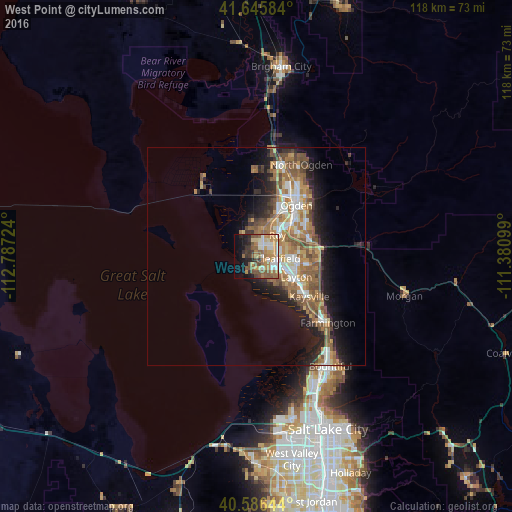
Analysis of West Point night lights 2016
Square area 10x10 km:
 6.33%
6.33%90-99
8.6%80-89
5.03%70-79
11.53%60-69
11.53%50-59
11.04%40-49
6.98%30-39
5.36%20-29
7.14%10-19
12.18%0-9
14.29%Square area 50x50 km:
2.12%90-99
2.32%80-89
1.4%70-79
2.58%60-69
3.44%50-59
3.91%40-49
2.28%30-39
1.69%20-29
3.61%10-19
6.99%0-9
69.66%Clear (daylight) street map image can be seen on geolist.org.
Map coordinates:
41° 38' 45" North, 112° 47' 14.1" West
41° 7' 5.8" North, 112° 5' 2.8" West
40° 35' 11.2" North, 111° 22' 51.6" West
Some cities around West Point sort by population:
• Roy
6.8 km =4.2 mi,  45°
45°
• Clearfield
4.9 km =3 mi,  99°
99°
• Syracuse
3.6 km =2.2 mi,  153°
153°
• Clinton
3.7 km =2.3 mi, 49°
• Washington Terrace
10.8 km =6.7 mi,  56°
56°
• Riverdale
9.4 km =5.8 mi, 45°
• Hooper
6 km =3.7 mi,  327°
327°
• Sunset
4.9 km =3 mi,  65°
65°
5784580 (p: 10,345)
Sources (retrieved 2019-11-25):
» Earth at Night: Flat Maps 2012, 2016