Sunset night lights from space
Night Light of Sunset (Utah) from space (United States) Src. Average luminocity for 10x10km area is 78.4432% and for 50x50km: 15.437%.
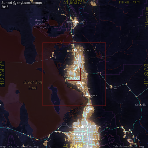
Analysis of Sunset night lights 2016
Square area 10x10 km:
 16.56%
90-99
20.13%80-89
9.42%70-79
17.37%60-69
21.43%50-59
11.04%40-49
2.76%30-39
1.3%20-29
0%10-19
0%0-9
0%Square area 50x50 km:
2.08%90-99
2.25%80-89
1.34%70-79
2.53%60-69
3.35%50-59
3.89%40-49
2.24%30-39
1.68%20-29
3.53%10-19
7.13%0-9
69.98%Clear (daylight) street map image can be seen on geolist.org.
Map coordinates:
41° 39' 49.5" North, 112° 44' 3" West
41° 8' 10.8" North, 112° 1' 51.8" West
40° 36' 16.7" North, 111° 19' 40.5" West
Some cities around Sunset sort by population:
• Roy
2.8 km =1.7 mi,  8°
8°
• Clearfield
2.9 km =1.8 mi,  171°
171°
• Syracuse
5.9 km =3.7 mi,  208°
208°
• Clinton
1.7 km =1.1 mi,  282°
282°
• West Haven
7.6 km =4.7 mi,  347°
347°
• West Point
4.9 km =3 mi,  245°
245°
• Washington Terrace
6.1 km =3.8 mi,  48°
48°
• Riverdale
5.1 km =3.2 mi,  26°
26°
5782320 (p: 5,183)
Sources (retrieved 2019-11-25):
» Earth at Night: Flat Maps 2012, 2016