Waianae night lights from space
Night Light of Waianae (Hawaii) from space (United States) Src. Average luminocity for 10x10km area is 24.0038% and for 50x50km: 11.2221%.
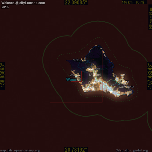
Analysis of Waianae night lights 2016
Square area 10x10 km:
 0.19%
0.19%90-99
1.33%80-89
0%70-79
3.6%60-69
9.28%50-59
5.3%40-49
6.82%30-39
7.95%20-29
3.03%10-19
18.18%0-9
44.32%Square area 50x50 km:
1.27%90-99
1.29%80-89
0.81%70-79
2.2%60-69
3.05%50-59
1.64%40-49
1.79%30-39
1.21%20-29
3.29%10-19
6.55%0-9
76.92%Clear (daylight) street map image can be seen on geolist.org.
Map coordinates:
22° 5' 27.1" North, 158° 53' 19.2" West
21° 26' 16.3" North, 158° 11' 8" West
20° 46' 54.9" North, 157° 28' 56.7" West
Some cities around Waianae sort by population:
• Makakilo
14 km =8.7 mi,  132°
132°
• Schofield Barracks
14.2 km =8.8 mi,  61°
61°
• Makakilo City
14.4 km =8.9 mi, 134°
• Royal Kunia
17.2 km =10.7 mi,  106°
106°
• Nānākuli
5.9 km =3.7 mi,  146°
146°
• Village Park
16.7 km =10.4 mi, 105°
• Mā‘ili
2.6 km =1.6 mi,  156°
156°
• Mākaha
4.1 km =2.5 mi,  320°
320°
5854189 (p: 13,177)
Sources (retrieved 2019-11-25):
» Earth at Night: Flat Maps 2012, 2016