Volney night lights from space
Night Light of Volney (New York) from space (United States) Src. Average luminocity for 10x10km area is 11.9429% and for 50x50km: 8.21%.
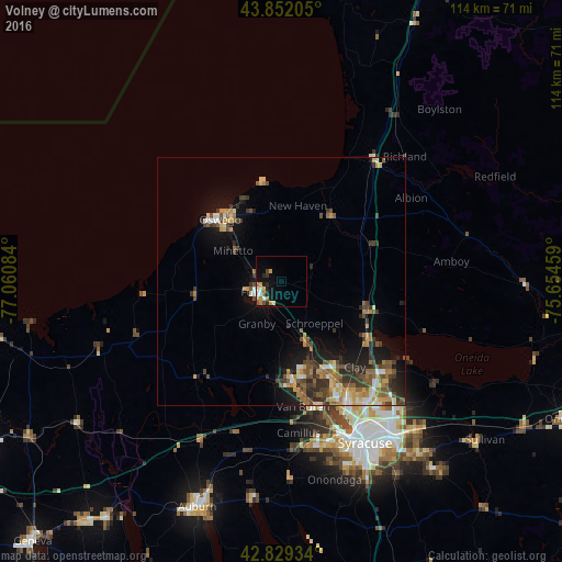
Analysis of Volney night lights 2016
Square area 10x10 km:
 0.95%
0.95%90-99
1.59%80-89
1.43%70-79
3.02%60-69
2.38%50-59
1.43%40-49
1.11%30-39
0.79%20-29
3.17%10-19
5.56%0-9
78.57%Square area 50x50 km:
0.55%90-99
0.96%80-89
1.03%70-79
1.38%60-69
1.28%50-59
1.5%40-49
1.72%30-39
1.64%20-29
2.04%10-19
4.79%0-9
83.11%Clear (daylight) street map image can be seen on geolist.org.
Map coordinates:
43° 51' 7.4" North, 77° 3' 39" West
43° 20' 34.3" North, 76° 21' 27.8" West
42° 49' 45.6" North, 75° 39' 16.5" West
Some cities around Volney sort by population:
• Oswego
17.6 km =10.9 mi,  315°
315°
• Fulton
5.3 km =3.3 mi,  245°
245°
• Fairmount
34.3 km =21.3 mi,  163°
163°
• Baldwinsville
20.6 km =12.8 mi,  174°
174°
• North Syracuse
29.6 km =18.4 mi,  141°
141°
• Mattydale
32.2 km =20 mi,  147°
147°
• Solvay
33.9 km =21.1 mi, 158°
• Richland
35.5 km =22.1 mi,  44°
44°
5142408 (p: 5,801)
Sources (retrieved 2019-11-25):
» Earth at Night: Flat Maps 2012, 2016