Fulton night lights from space
Night Light of Fulton (New York) from space (United States) Src. Average luminocity for 10x10km area is 17.9242% and for 50x50km: 8.3656%.
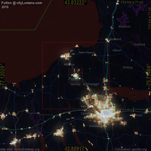
Analysis of Fulton night lights 2016
Square area 10x10 km:
 1.36%
1.36%90-99
2.27%80-89
1.97%70-79
4.09%60-69
2.88%50-59
1.97%40-49
2.27%30-39
1.97%20-29
3.03%10-19
10.3%0-9
67.88%Square area 50x50 km:
0.77%90-99
1.16%80-89
1.12%70-79
1.44%60-69
1.19%50-59
1.33%40-49
1.51%30-39
1.73%20-29
1.76%10-19
4.44%0-9
83.54%Clear (daylight) street map image can be seen on geolist.org.
Map coordinates:
43° 49' 56" North, 77° 7' 13" West
43° 19' 22.3" North, 76° 25' 1.8" West
42° 48' 33" North, 75° 42' 50.5" West
Some cities around Fulton sort by population:
• Oswego
16.6 km =10.3 mi,  332°
332°
• Fairmount
33.9 km =21.1 mi,  154°
154°
• Baldwinsville
19.5 km =12.1 mi,  159°
159°
• North Syracuse
31.3 km =19.4 mi,  131°
131°
• Mattydale
33.3 km =20.7 mi,  138°
138°
• Solvay
34 km =21.1 mi, 149°
• Volney
5.3 km =3.3 mi,  65°
65°
• Centerport
34.4 km =21.4 mi,  204°
204°
5118136 (p: 11,552)
Sources (retrieved 2019-11-25):
» Earth at Night: Flat Maps 2012, 2016