Valparaiso night lights from space
Night Light of Valparaiso (Florida) from space (United States) Src. Average luminocity for 10x10km area is 52.1209% and for 50x50km: 14.0539%.
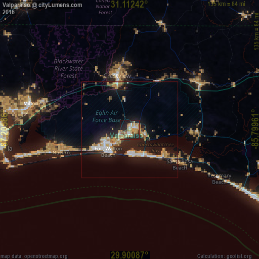
Analysis of Valparaiso night lights 2016
Square area 10x10 km:
 6.23%
6.23%90-99
6.78%80-89
10.44%70-79
12.82%60-69
13.37%50-59
2.93%40-49
3.66%30-39
6.04%20-29
21.25%10-19
14.29%0-9
2.2%Square area 50x50 km:
1.92%90-99
1.63%80-89
2.09%70-79
2.32%60-69
2.48%50-59
0.72%40-49
1.27%30-39
1.28%20-29
4.97%10-19
13.91%0-9
67.4%Clear (daylight) street map image can be seen on geolist.org.
Map coordinates:
31° 6' 44.7" North, 87° 12' 21.1" West
30° 30' 30.7" North, 86° 30' 9.8" West
29° 54' 3.1" North, 85° 47' 58.6" West
Some cities around Valparaiso sort by population:
• Wright
14.3 km =8.9 mi,  245°
245°
• Fort Walton Beach
14.7 km =9.1 mi,  228°
228°
• Niceville
2.2 km =1.4 mi,  64°
64°
• Destin
12.8 km =8 mi,  177°
177°
• Lake Lorraine
9.6 km =6 mi,  218°
218°
• Eglin Village
6.2 km =3.9 mi,  214°
214°
• Miramar Beach
20.3 km =12.6 mi,  137°
137°
• Ocean City
13 km =8.1 mi, 234°
4176316 (p: 5,023)
Sources (retrieved 2019-11-25):
» Earth at Night: Flat Maps 2012, 2016