Lake Lorraine night lights from space
Night Light of Lake Lorraine (Florida) from space (United States) Src. Average luminocity for 10x10km area is 52.3681% and for 50x50km: 12.7498%.
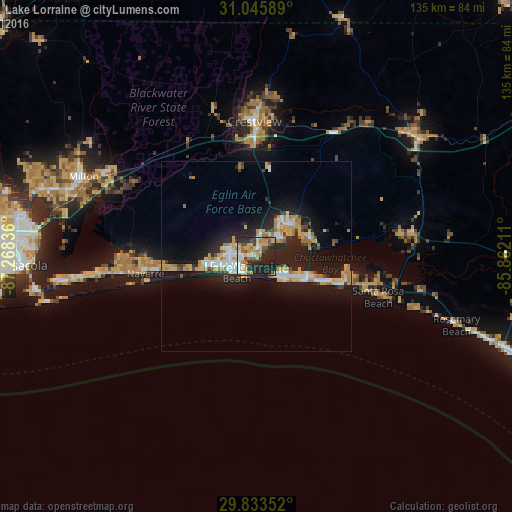
Analysis of Lake Lorraine night lights 2016
Square area 10x10 km:
 9.71%
9.71%90-99
5.86%80-89
10.62%70-79
7.51%60-69
10.07%50-59
4.03%40-49
7.69%30-39
6.59%20-29
24.73%10-19
13.19%0-9
0%Square area 50x50 km:
1.86%90-99
1.58%80-89
2.02%70-79
1.99%60-69
2.2%50-59
0.51%40-49
1.08%30-39
1.13%20-29
4.61%10-19
12.46%0-9
70.57%Clear (daylight) street map image can be seen on geolist.org.
Map coordinates:
31° 2' 45.2" North, 87° 16' 6.1" West
30° 26' 29.7" North, 86° 33' 54.8" West
29° 50' 0.7" North, 85° 51' 43.6" West
Some cities around Lake Lorraine sort by population:
• Wright
7.2 km =4.5 mi,  282°
282°
• Fort Walton Beach
5.5 km =3.4 mi,  244°
244°
• Niceville
11.5 km =7.1 mi,  43°
43°
• Destin
8.5 km =5.3 mi,  128°
128°
• Eglin Village
3.4 km =2.1 mi,  46°
46°
• Miramar Beach
21.2 km =13.2 mi,  110°
110°
• Ocean City
4.6 km =2.9 mi,  269°
269°
• Valparaiso
9.6 km =6 mi, 38°
4161296 (p: 7,010)
Sources (retrieved 2019-11-25):
» Earth at Night: Flat Maps 2012, 2016