Tillmans Corner night lights from space
Night Light of Tillmans Corner (Alabama) from space (United States) Src. Average luminocity for 10x10km area is 77.8645% and for 50x50km: 33.7876%.
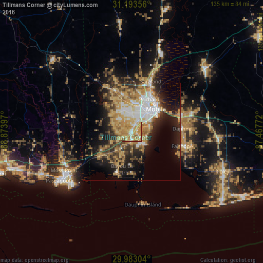
Analysis of Tillmans Corner night lights 2016
Square area 10x10 km:
 7.51%
7.51%90-99
11.72%80-89
19.23%70-79
35.35%60-69
21.98%50-59
3.11%40-49
0.55%30-39
0.55%20-29
0%10-19
0%0-9
0%Square area 50x50 km:
5.34%90-99
4.35%80-89
6.35%70-79
6.76%60-69
6.23%50-59
3.46%40-49
4.41%30-39
4.93%20-29
6.88%10-19
12.45%0-9
38.84%Clear (daylight) street map image can be seen on geolist.org.
Map coordinates:
31° 11' 36.8" North, 88° 52' 26.3" West
30° 35' 24.7" North, 88° 10' 15" West
29° 58' 58.9" North, 87° 28' 3.8" West
Some cities around Tillmans Corner sort by population:
• Mobile
16.8 km =10.4 mi,  46°
46°
• Daphne
25.6 km =15.9 mi,  86°
86°
• Prichard
18.7 km =11.6 mi,  28°
28°
• Fairhope
26.7 km =16.6 mi,  106°
106°
• Saraland
27.4 km =17 mi,  20°
20°
• Spanish Fort
26.2 km =16.3 mi,  68°
68°
• Theodore
4.7 km =2.9 mi,  185°
185°
• Chickasaw
21.4 km =13.3 mi, 25°
4093753 (p: 17,398)
Sources (retrieved 2019-11-25):
» Earth at Night: Flat Maps 2012, 2016