Prichard night lights from space
Night Light of Prichard (Alabama) from space (United States) Src. Average luminocity for 10x10km area is 85.9178% and for 50x50km: 37.0517%.
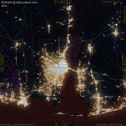

Analysis of Prichard night lights 2016
Square area 10x10 km:
 35.49%
90-99
25%80-89
9.44%70-79
14.69%60-69
3.67%50-59
2.97%40-49
3.32%30-39
2.62%20-29
2.8%10-19
0%0-9
0%Square area 50x50 km:
5.81%90-99
4.83%80-89
6.47%70-79
7.86%60-69
7.57%50-59
3.74%40-49
4.39%30-39
5.2%20-29
7.61%10-19
13.96%0-9
32.57%Clear (daylight) street map image can be seen on geolist.org.
Map coordinates:
31° 20' 28.5" North, 88° 46' 55.3" West
30° 44' 19.7" North, 88° 4' 44" West
30° 7' 57.3" North, 87° 22' 32.8" West
Some cities around Prichard sort by population:
• Mobile
6 km =3.7 mi,  145°
145°
• Daphne
22.5 km =14 mi,  131°
131°
• Tillmans Corner
18.7 km =11.6 mi,  208°
208°
• Saraland
9.1 km =5.7 mi,  4°
4°
• Spanish Fort
17.2 km =10.7 mi,  114°
114°
• Satsuma
12.9 km =8 mi,  9°
9°
• Theodore
23.2 km =14.4 mi,  203°
203°
• Chickasaw
2.8 km =1.7 mi, 8°
4084888 (p: 22,351)
Sources (retrieved 2019-11-25):
» Earth at Night: Flat Maps 2012, 2016