Thermalito night lights from space
Night Light of Thermalito (California) from space (United States) Src. Average luminocity for 10x10km area is 26.7468% and for 50x50km: 3.3672%.
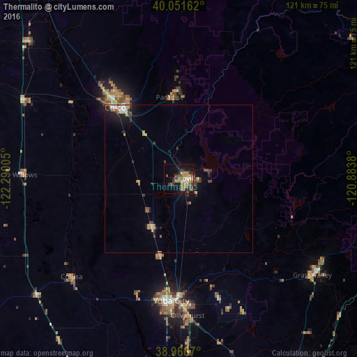
Analysis of Thermalito night lights 2016
Square area 10x10 km:
 1.79%
1.79%90-99
2.11%80-89
0.32%70-79
7.79%60-69
6.66%50-59
5.68%40-49
5.36%30-39
6.17%20-29
2.76%10-19
20.62%0-9
40.75%Square area 50x50 km:
0.28%90-99
0.34%80-89
0.09%70-79
0.76%60-69
0.54%50-59
0.42%40-49
0.61%30-39
0.78%20-29
0.71%10-19
2.51%0-9
92.96%Clear (daylight) street map image can be seen on geolist.org.
Map coordinates:
40° 3' 5.8" North, 122° 17' 24.2" West
39° 30' 40.6" North, 121° 35' 12.9" West
38° 58' 0.1" North, 120° 53' 1.7" West
Some cities around Thermalito sort by population:
• Paradise
27.8 km =17.3 mi,  353°
353°
• Oroville
2.5 km =1.6 mi,  83°
83°
• Live Oak
26.9 km =16.7 mi,  193°
193°
• Oroville East
9.6 km =6 mi,  90°
90°
• Gridley
18.8 km =11.7 mi,  209°
209°
• South Oroville
3.4 km =2.1 mi,  118°
118°
• Durham
23.6 km =14.7 mi,  309°
309°
• Palermo
9.4 km =5.8 mi,  153°
153°
5402159 (p: 6,646)
Sources (retrieved 2019-11-25):
» Earth at Night: Flat Maps 2012, 2016