Crossville night lights from space
Night Light of Crossville (Tennessee) from space (United States) Src. Average luminocity for 10x10km area is 52.2179% and for 50x50km: 5.0751%.
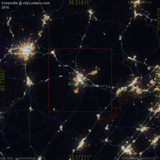
Analysis of Crossville night lights 2016
Square area 10x10 km:
 7.69%
7.69%90-99
6.78%80-89
8.24%70-79
8.61%60-69
12.27%50-59
8.42%40-49
5.86%30-39
8.24%20-29
16.3%10-19
17.58%0-9
0%Square area 50x50 km:
0.36%90-99
0.36%80-89
0.59%70-79
0.7%60-69
0.88%50-59
1.04%40-49
0.65%30-39
1.42%20-29
1.24%10-19
3.62%0-9
89.14%Clear (daylight) street map image can be seen on geolist.org.
Map coordinates:
36° 30' 58" North, 85° 43' 48.1" West
35° 56' 56.3" North, 85° 1' 36.8" West
35° 22' 39.8" North, 84° 19' 25.6" West
Some cities around Crossville sort by population:
• Cookeville
48.9 km =30.4 mi,  299°
299°
• Dayton
50.6 km =31.4 mi,  178°
178°
• Fairfield Glade
13.9 km =8.6 mi,  65°
65°
• Harriman
42.7 km =26.5 mi,  92°
92°
• Sweetwater
64 km =39.8 mi,  127°
127°
• Kingston
47.3 km =29.4 mi,  99°
99°
• Rockwood
32.2 km =20 mi,  106°
106°
• Sparta
39.4 km =24.5 mi,  266°
266°
4616470 (p: 11,411)
Sources (retrieved 2019-11-25):
» Earth at Night: Flat Maps 2012, 2016