Siesta Key night lights from space
Night Light of Siesta Key (Florida) from space (United States) Src. Average luminocity for 10x10km area is 53.9053% and for 50x50km: 27.9791%.
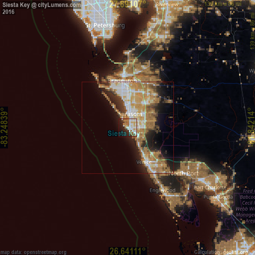
Analysis of Siesta Key night lights 2016
Square area 10x10 km:
 13.26%
90-99
14.39%80-89
4.73%70-79
4.36%60-69
11.74%50-59
5.87%40-49
3.22%30-39
2.84%20-29
14.02%10-19
16.86%0-9
8.71%Square area 50x50 km:
4.56%90-99
5.12%80-89
3.14%70-79
5.37%60-69
7.82%50-59
3.09%40-49
2.32%30-39
2.91%20-29
5.68%10-19
8.12%0-9
51.86%Clear (daylight) street map image can be seen on geolist.org.
Map coordinates:
27° 53' 27.9" North, 83° 14' 54.2" West
27° 16' 4.3" North, 82° 32' 42.9" West
26° 38' 28" North, 81° 50' 31.7" West
Some cities around Siesta Key sort by population:
• Sarasota
7.8 km =4.8 mi,  10°
10°
• Sarasota Springs
7.9 km =4.9 mi,  54°
54°
• Fruitville
11.1 km =6.9 mi, 51°
• Gulf Gate Estates
3.5 km =2.2 mi,  120°
120°
• Bee Ridge
6.6 km =4.1 mi,  74°
74°
• Southgate
5.7 km =3.5 mi,  38°
38°
• Osprey
9.6 km =6 mi,  145°
145°
• South Gate Ridge
5.2 km =3.2 mi, 66°
4172935 (p: 6,565)
Sources (retrieved 2019-11-25):
» Earth at Night: Flat Maps 2012, 2016