Cypress Gardens night lights from space
Night Light of Cypress Gardens (Florida) from space (United States) Src. Average luminocity for 10x10km area is 70.3447% and for 50x50km: 35.535%.
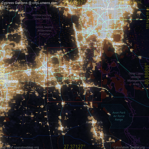
Analysis of Cypress Gardens night lights 2016
Square area 10x10 km:
 8.9%
8.9%90-99
12.69%80-89
7.39%70-79
11.36%60-69
31.06%50-59
19.32%40-49
8.9%30-39
0.38%20-29
0%10-19
0%0-9
0%Square area 50x50 km:
2.77%90-99
3.83%80-89
2.42%70-79
3.48%60-69
14.66%50-59
7.16%40-49
7.7%30-39
7.48%20-29
9.13%10-19
13.73%0-9
27.63%Clear (daylight) street map image can be seen on geolist.org.
Map coordinates:
28° 36' 46.7" North, 82° 23' 35.6" West
27° 59' 38.1" North, 81° 41' 24.3" West
27° 22' 16.6" North, 80° 59' 13.1" West
Some cities around Cypress Gardens sort by population:
• Winter Haven
5.2 km =3.2 mi,  306°
306°
• Haines City
15.1 km =9.4 mi,  27°
27°
• Lake Wales
14.5 km =9 mi,  135°
135°
• Auburndale
12.5 km =7.8 mi, 309°
• Inwood
8.8 km =5.5 mi,  303°
303°
• Jan-Phyl Village
8.3 km =5.2 mi,  286°
286°
• Lake Alfred
11.4 km =7.1 mi,  343°
343°
• Wahneta
5.8 km =3.6 mi,  218°
218°
4152628 (p: 8,917)
Sources (retrieved 2019-11-25):
» Earth at Night: Flat Maps 2012, 2016