Bartow night lights from space
Night Light of Bartow (Florida) from space (United States) Src. Average luminocity for 10x10km area is 49.3125% and for 50x50km: 35.5345%.
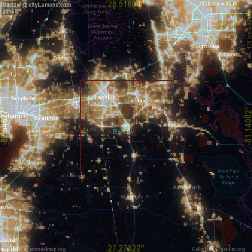
Analysis of Bartow night lights 2016
Square area 10x10 km:
 7.39%
7.39%90-99
7.39%80-89
1.52%70-79
4.92%60-69
13.83%50-59
6.06%40-49
13.64%30-39
15.15%20-29
14.96%10-19
14.96%0-9
0.19%Square area 50x50 km:
4.33%90-99
5.12%80-89
2.79%70-79
4.14%60-69
14.05%50-59
7.5%40-49
5.88%30-39
5.53%20-29
5.71%10-19
6.69%0-9
38.27%Clear (daylight) street map image can be seen on geolist.org.
Map coordinates:
28° 30' 57.7" North, 82° 32' 46.6" West
27° 53' 47.1" North, 81° 50' 35.3" West
27° 16' 23.6" North, 81° 8' 24.1" West
Some cities around Bartow sort by population:
• Lakeland Highlands
12.6 km =7.8 mi,  303°
303°
• Highland City
8.4 km =5.2 mi,  335°
335°
• Medulla
15.1 km =9.4 mi, 301°
• Fuller Heights
15.3 km =9.5 mi,  275°
275°
• Fort Meade
16.5 km =10.3 mi,  165°
165°
• Jan-Phyl Village
14.9 km =9.3 mi,  28°
28°
• Crystal Lake
16.7 km =10.4 mi, 337°
• Wahneta
13 km =8.1 mi,  61°
61°
4146723 (p: 18,972)
Sources (retrieved 2019-11-25):
» Earth at Night: Flat Maps 2012, 2016