Prosper night lights from space
Night Light of Prosper (Texas) from space (United States) Src. Average luminocity for 10x10km area is 60.5507% and for 50x50km: 45.7261%.
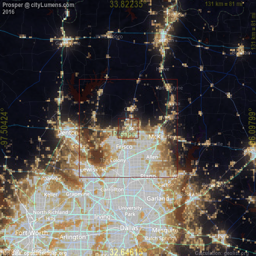
Analysis of Prosper night lights 2016
Square area 10x10 km:
 5.07%
5.07%90-99
8.22%80-89
8.22%70-79
13.29%60-69
16.43%50-59
18.01%40-49
11.89%30-39
6.47%20-29
7.34%10-19
5.07%0-9
0%Square area 50x50 km:
10.88%90-99
10.9%80-89
7.12%70-79
6.08%60-69
6.32%50-59
5.49%40-49
4.18%30-39
4.51%20-29
5.81%10-19
7.93%0-9
30.79%Clear (daylight) street map image can be seen on geolist.org.
Map coordinates:
33° 49' 20.5" North, 97° 30' 15.3" West
33° 14' 10.4" North, 96° 48' 4" West
32° 38' 46.1" North, 96° 5' 52.8" West
Some cities around Prosper sort by population:
• McKinney
17.8 km =11.1 mi,  103°
103°
• Frisco
9.7 km =6 mi,  192°
192°
• Allen
19.1 km =11.9 mi,  140°
140°
• The Colony
18.2 km =11.3 mi,  205°
205°
• Little Elm
15.1 km =9.4 mi,  237°
237°
• Fairview
18 km =11.2 mi,  118°
118°
• Celina
9.9 km =6.2 mi,  8°
8°
• Melissa
21.9 km =13.6 mi,  75°
75°
4720833 (p: 15,967)
Sources (retrieved 2019-11-25):
» Earth at Night: Flat Maps 2012, 2016