Celina night lights from space
Night Light of Celina (Texas) from space (United States) Src. Average luminocity for 10x10km area is 21.9895% and for 50x50km: 29.5811%.
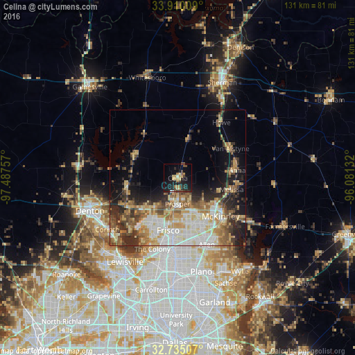
Analysis of Celina night lights 2016
Square area 10x10 km:
 0.52%
0.52%90-99
0.87%80-89
4.02%70-79
4.37%60-69
2.8%50-59
2.62%40-49
4.37%30-39
1.92%20-29
8.22%10-19
27.62%0-9
42.66%Square area 50x50 km:
5.26%90-99
5.55%80-89
4.88%70-79
4.1%60-69
4.29%50-59
4.43%40-49
3.73%30-39
4.03%20-29
5.67%10-19
8.66%0-9
49.4%Clear (daylight) street map image can be seen on geolist.org.
Map coordinates:
33° 54' 36.3" North, 97° 29' 15.3" West
33° 19' 28.4" North, 96° 47' 4" West
32° 44' 6.3" North, 96° 4' 52.8" West
Some cities around Celina sort by population:
• McKinney
21.1 km =13.1 mi,  131°
131°
• Frisco
19.7 km =12.2 mi,  190°
190°
• Allen
26.8 km =16.7 mi,  156°
156°
• Little Elm
23 km =14.3 mi,  218°
218°
• Prosper
9.9 km =6.2 mi, 188°
• Anna
22.1 km =13.7 mi,  82°
82°
• Fairview
23.4 km =14.5 mi,  142°
142°
• Melissa
20.1 km =12.5 mi,  102°
102°
4679944 (p: 7,697)
Sources (retrieved 2019-11-25):
» Earth at Night: Flat Maps 2012, 2016