Plover night lights from space
Night Light of Plover (Wisconsin) from space (United States) Src. Average luminocity for 10x10km area is 27.1365% and for 50x50km: 4.7177%.
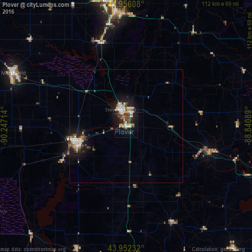
Analysis of Plover night lights 2016
Square area 10x10 km:
 2.06%
2.06%90-99
1.75%80-89
4.76%70-79
2.7%60-69
3.81%50-59
6.03%40-49
8.1%30-39
1.27%20-29
9.21%10-19
28.1%0-9
32.22%Square area 50x50 km:
0.65%90-99
0.68%80-89
0.68%70-79
0.39%60-69
0.47%50-59
0.69%40-49
0.84%30-39
0.48%20-29
1.33%10-19
4.16%0-9
89.62%Clear (daylight) street map image can be seen on geolist.org.
Map coordinates:
44° 57' 21.9" North, 90° 14' 49.7" West
44° 27' 22.9" North, 89° 32' 38.4" West
43° 57' 8.4" North, 88° 50' 27.2" West
Some cities around Plover sort by population:
• Stevens Point
7.9 km =4.9 mi,  342°
342°
• Marshfield
55.1 km =34.2 mi,  295°
295°
• Wisconsin Rapids
23.2 km =14.4 mi,  249°
249°
• Weston
48.3 km =30 mi,  359°
359°
• Kronenwetter
40.8 km =25.4 mi,  354°
354°
• Waupaca
38 km =23.6 mi,  106°
106°
• Rib Mountain
51.8 km =32.2 mi, 348°
• Rothschild
48.3 km =30 mi, 352°
5267537 (p: 12,319)
Sources (retrieved 2019-11-25):
» Earth at Night: Flat Maps 2012, 2016