Marshfield night lights from space
Night Light of Marshfield (Wisconsin) from space (United States) Src. Average luminocity for 10x10km area is 34.9212% and for 50x50km: 2.2611%.
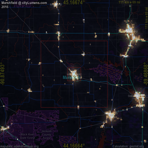
Analysis of Marshfield night lights 2016
Square area 10x10 km:
 5%
5%90-99
7.73%80-89
3.64%70-79
3.18%60-69
7.42%50-59
4.7%40-49
3.48%30-39
1.36%20-29
4.85%10-19
36.82%0-9
21.82%Square area 50x50 km:
0.23%90-99
0.37%80-89
0.29%70-79
0.22%60-69
0.4%50-59
0.3%40-49
0.23%30-39
0.27%20-29
0.4%10-19
1.91%0-9
95.38%Clear (daylight) street map image can be seen on geolist.org.
Map coordinates:
45° 10' 0.3" North, 90° 52' 29.7" West
44° 40' 7.9" North, 90° 10' 18.5" West
44° 9' 59.9" North, 89° 28' 7.2" West
Some cities around Marshfield sort by population:
• Wausau
53.5 km =33.2 mi,  52°
52°
• Stevens Point
50 km =31.1 mi,  108°
108°
• Wisconsin Rapids
42.4 km =26.3 mi,  138°
138°
• Weston
55.1 km =34.2 mi,  63°
63°
• Plover
55.1 km =34.2 mi,  115°
115°
• Kronenwetter
49 km =30.4 mi,  69°
69°
• Rib Mountain
47.6 km =29.6 mi, 55°
• Rothschild
49.9 km =31 mi, 60°
5261969 (p: 18,620)
Sources (retrieved 2019-11-25):
» Earth at Night: Flat Maps 2012, 2016