Pinehurst night lights from space
Night Light of Pinehurst (Massachusetts) from space (United States) Src. Average luminocity for 10x10km area is 68.9206% and for 50x50km: 53.0572%.
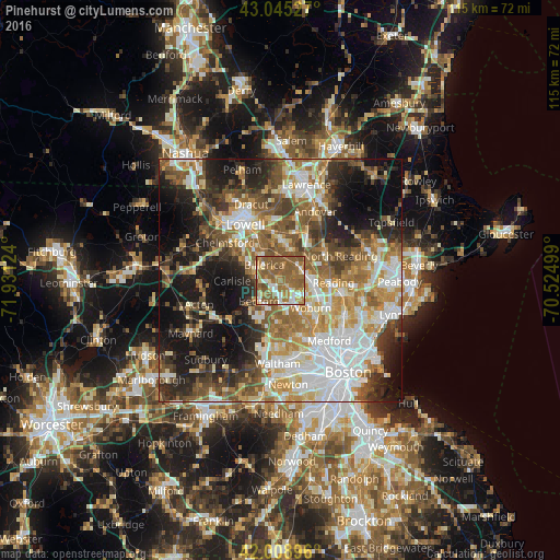
Analysis of Pinehurst night lights 2016
Square area 10x10 km:
 9.21%
9.21%90-99
9.37%80-89
6.67%70-79
9.05%60-69
26.98%50-59
35.08%40-49
3.65%30-39
0%20-29
0%10-19
0%0-9
0%Square area 50x50 km:
11.56%90-99
10.04%80-89
6.3%70-79
6.91%60-69
8.94%50-59
9.51%40-49
7.11%30-39
6.34%20-29
9.8%10-19
15.5%0-9
8%Clear (daylight) street map image can be seen on geolist.org.
Map coordinates:
43° 2' 43" North, 71° 55' 52.5" West
42° 31' 45.3" North, 71° 13' 41.2" West
42° 0' 32.3" North, 70° 31' 30" West
Some cities around Pinehurst sort by population:
• Billerica
4.7 km =2.9 mi,  314°
314°
• Woburn
8.3 km =5.2 mi,  131°
131°
• Lexington
9.1 km =5.7 mi,  178°
178°
• Tewksbury
9.1 km =5.7 mi,  356°
356°
• Reading
10.9 km =6.8 mi,  92°
92°
• Burlington
3.8 km =2.4 mi,  135°
135°
• Wilmington
4.9 km =3 mi,  66°
66°
• Bedford
5.8 km =3.6 mi,  222°
222°
4947397 (p: 7,152)
Sources (retrieved 2019-11-25):
» Earth at Night: Flat Maps 2012, 2016