Pine Hill night lights from space
Night Light of Pine Hill (New Jersey) from space (United States) Src. Average luminocity for 10x10km area is 76.9252% and for 50x50km: 50.8409%.
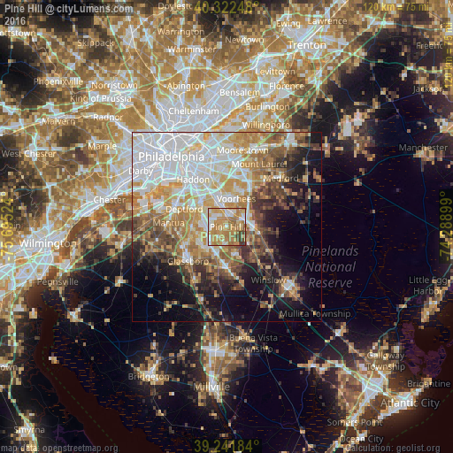
Analysis of Pine Hill night lights 2016
Square area 10x10 km:
 12.93%
90-99
14.12%80-89
12.41%70-79
26.53%60-69
22.62%50-59
4.76%40-49
4.59%30-39
2.04%20-29
0%10-19
0%0-9
0%Square area 50x50 km:
13.91%90-99
9.63%80-89
6.17%70-79
8.37%60-69
7.58%50-59
5.69%40-49
5.81%30-39
5.64%20-29
5.22%10-19
11.67%0-9
20.29%Clear (daylight) street map image can be seen on geolist.org.
Map coordinates:
40° 19' 20.9" North, 75° 41' 42.9" West
39° 47' 3.4" North, 74° 59' 31.6" West
39° 14' 30.6" North, 74° 17' 20.4" West
Some cities around Pine Hill sort by population:
• Sicklerville
7.7 km =4.8 mi,  165°
165°
• Lindenwold
4.5 km =2.8 mi,  353°
353°
• Atco
9.1 km =5.7 mi,  100°
100°
• Echelon
7.1 km =4.4 mi,  357°
357°
• Ashland
8.9 km =5.5 mi, 352°
• Berlin
5.4 km =3.4 mi,  81°
81°
• Stratford
5.1 km =3.2 mi,  337°
337°
• Somerdale
7.1 km =4.4 mi, 338°
4503606 (p: 10,510)
Sources (retrieved 2019-11-25):
» Earth at Night: Flat Maps 2012, 2016