Lindenwold night lights from space
Night Light of Lindenwold (New Jersey) from space (United States) Src. Average luminocity for 10x10km area is 85.6548% and for 50x50km: 57.6152%.
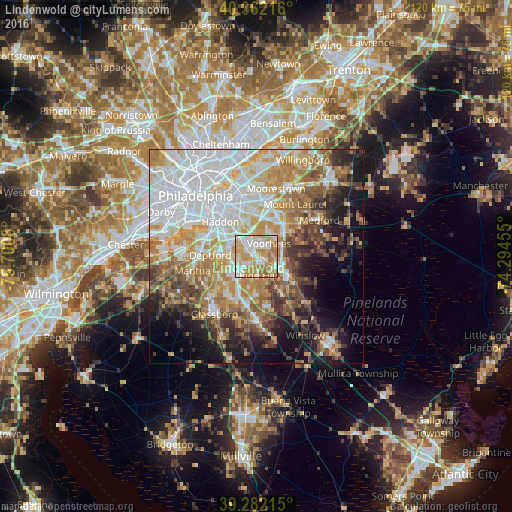
Analysis of Lindenwold night lights 2016
Square area 10x10 km:
 20.75%
90-99
23.3%80-89
20.58%70-79
21.43%60-69
11.9%50-59
2.04%40-49
0%30-39
0%20-29
0%10-19
0%0-9
0%Square area 50x50 km:
17.33%90-99
11.33%80-89
7.08%70-79
9.37%60-69
8.38%50-59
5.87%40-49
5.69%30-39
5.77%20-29
5.13%10-19
10.47%0-9
13.58%Clear (daylight) street map image can be seen on geolist.org.
Map coordinates:
40° 21' 43.8" North, 75° 42' 2.9" West
39° 49' 27.4" North, 74° 59' 51.6" West
39° 16' 55.7" North, 74° 17' 40.4" West
Some cities around Lindenwold sort by population:
• Echelon
2.7 km =1.7 mi,  3°
3°
• Pine Hill
4.5 km =2.8 mi,  173°
173°
• Runnemede
6.8 km =4.2 mi,  297°
297°
• Ashland
4.4 km =2.7 mi,  350°
350°
• Berlin
6.9 km =4.3 mi,  122°
122°
• Stratford
1.5 km =0.9 mi,  280°
280°
• Barrington
6.7 km =4.2 mi,  312°
312°
• Somerdale
3.1 km =1.9 mi,  315°
315°
4502687 (p: 17,613)
Sources (retrieved 2019-11-25):
» Earth at Night: Flat Maps 2012, 2016