Pike Creek Valley night lights from space
Night Light of Pike Creek Valley (Delaware) from space (United States) Src. Average luminocity for 10x10km area is 71.2581% and for 50x50km: 40.1361%.
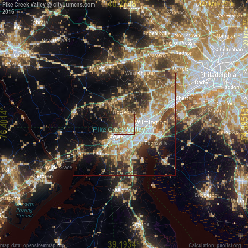
Analysis of Pike Creek Valley night lights 2016
Square area 10x10 km:
 7.79%
7.79%90-99
12.66%80-89
16.23%70-79
14.29%60-69
22.24%50-59
13.64%40-49
7.31%30-39
4.06%20-29
1.79%10-19
0%0-9
0%Square area 50x50 km:
5.4%90-99
6.8%80-89
5.43%70-79
6.57%60-69
7.22%50-59
6.91%40-49
6.45%30-39
7.19%20-29
8.42%10-19
13.39%0-9
26.21%Clear (daylight) street map image can be seen on geolist.org.
Map coordinates:
40° 16' 29.3" North, 76° 24' 5" West
39° 44' 10.4" North, 75° 41' 53.8" West
39° 11' 36.2" North, 74° 59' 42.5" West
Some cities around Pike Creek Valley sort by population:
• Newark
7.3 km =4.5 mi,  216°
216°
• Bear
12.4 km =7.7 mi,  163°
163°
• Brookside
8.1 km =5 mi,  197°
197°
• Hockessin
5.7 km =3.5 mi,  1°
1°
• North Star
3.3 km =2.1 mi,  327°
327°
• Wilmington Manor
11.2 km =7 mi,  119°
119°
• Kennett Square
12.3 km =7.6 mi,  354°
354°
• Elsmere
8.6 km =5.3 mi,  87°
87°
4144101 (p: 11,217)
Sources (retrieved 2019-11-25):
» Earth at Night: Flat Maps 2012, 2016