Brookside night lights from space
Night Light of Brookside (Delaware) from space (United States) Src. Average luminocity for 10x10km area is 84.2159% and for 50x50km: 36.2457%.
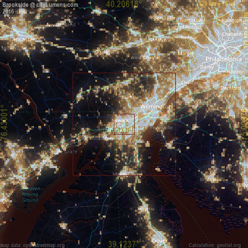
Analysis of Brookside night lights 2016
Square area 10x10 km:
 19.32%
90-99
29.38%80-89
12.99%70-79
17.69%60-69
15.26%50-59
3.57%40-49
0.97%30-39
0.81%20-29
0%10-19
0%0-9
0%Square area 50x50 km:
5.17%90-99
6.36%80-89
5.15%70-79
5.83%60-69
6.42%50-59
5.3%40-49
5.24%30-39
6.42%20-29
8.41%10-19
11.87%0-9
33.84%Clear (daylight) street map image can be seen on geolist.org.
Map coordinates:
40° 12' 22.2" North, 76° 25' 48" West
39° 40' 1.4" North, 75° 43' 36.8" West
39° 7' 25.3" North, 75° 1' 25.5" West
Some cities around Brookside sort by population:
• Newark
2.7 km =1.7 mi,  313°
313°
• Bear
7.2 km =4.5 mi,  125°
125°
• Elkton
11.3 km =7 mi,  233°
233°
• Glasgow
7.1 km =4.4 mi,  192°
192°
• Pike Creek Valley
8.1 km =5 mi,  17°
17°
• North Star
10.5 km =6.5 mi,  3°
3°
• Pike Creek
7.4 km =4.6 mi, 15°
• Wilmington Manor
12.4 km =7.7 mi,  79°
79°
4141674 (p: 14,353)
Sources (retrieved 2019-11-25):
» Earth at Night: Flat Maps 2012, 2016