Paxtonia night lights from space
Night Light of Paxtonia (Pennsylvania) from space (United States) Src. Average luminocity for 10x10km area is 63.8214% and for 50x50km: 25.9212%.
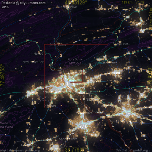
Analysis of Paxtonia night lights 2016
Square area 10x10 km:
 9.01%
9.01%90-99
12.59%80-89
9.35%70-79
6.29%60-69
17.69%50-59
17.18%40-49
8.16%30-39
10.71%20-29
7.82%10-19
1.19%0-9
0%Square area 50x50 km:
3.78%90-99
4.15%80-89
3.67%70-79
3.55%60-69
3.86%50-59
3.83%40-49
3.48%30-39
4.02%20-29
6.95%10-19
16.99%0-9
45.72%Clear (daylight) street map image can be seen on geolist.org.
Map coordinates:
40° 51' 4.6" North, 77° 29' 51.2" West
40° 19' 2.3" North, 76° 47' 39.9" West
39° 46' 44.7" North, 76° 5' 28.7" West
Some cities around Paxtonia sort by population:
• Harrisburg
9 km =5.6 mi,  237°
237°
• Hershey
12.7 km =7.9 mi,  105°
105°
• Colonial Park
2.3 km =1.4 mi,  214°
214°
• Progress
4.8 km =3 mi,  221°
221°
• New Cumberland
12.2 km =7.6 mi, 219°
• Linglestown
1.9 km =1.2 mi,  13°
13°
• Enola
12.2 km =7.6 mi,  255°
255°
• Steelton
9.9 km =6.2 mi,  203°
203°
5205267 (p: 5,412)
Sources (retrieved 2019-11-25):
» Earth at Night: Flat Maps 2012, 2016