Pascagoula night lights from space
Night Light of Pascagoula (Mississippi) from space (United States) Src. Average luminocity for 10x10km area is 65.2179% and for 50x50km: 15.0026%.

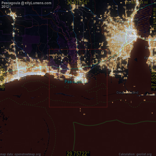
Analysis of Pascagoula night lights 2016
Square area 10x10 km:
 17.95%
90-99
18.68%80-89
9.71%70-79
9.16%60-69
2.01%50-59
3.66%40-49
4.03%30-39
11.36%20-29
17.58%10-19
5.86%0-9
0%Square area 50x50 km:
1.16%90-99
1.33%80-89
2.15%70-79
2.22%60-69
2.62%50-59
1.88%40-49
2.78%30-39
3.22%20-29
6.28%10-19
11.07%0-9
65.3%Clear (daylight) street map image can be seen on geolist.org.
Map coordinates:
30° 58' 13.9" North, 89° 15' 33.3" West
30° 21' 56.7" North, 88° 33' 22.1" West
29° 45' 26" North, 87° 51' 10.8" West
Some cities around Pascagoula sort by population:
• Biloxi
31.8 km =19.8 mi,  276°
276°
• Gautier
5.8 km =3.6 mi,  292°
292°
• Ocean Springs
26.5 km =16.5 mi, 280°
• Moss Point
5.5 km =3.4 mi,  22°
22°
• Saint Martin
31 km =19.3 mi, 285°
• Gulf Hills
28.4 km =17.6 mi, 284°
• Vancleave
23.2 km =14.4 mi,  327°
327°
• Gulf Park Estates
19.9 km =12.4 mi, 278°
4440397 (p: 22,126)
Sources (retrieved 2019-11-25):
» Earth at Night: Flat Maps 2012, 2016