Ormond-by-the-Sea night lights from space
Night Light of Ormond-by-the-Sea (Florida) from space (United States) Src. Average luminocity for 10x10km area is 26.3769% and for 50x50km: 16.3318%.
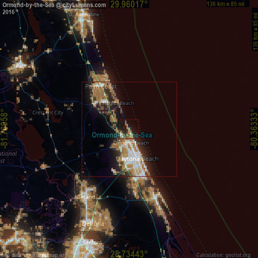
Analysis of Ormond-by-the-Sea night lights 2016
Square area 10x10 km:
 1.33%
1.33%90-99
1.33%80-89
0.38%70-79
1.33%60-69
14.77%50-59
4.92%40-49
4.17%30-39
2.46%20-29
9.28%10-19
29.17%0-9
30.87%Square area 50x50 km:
2.52%90-99
2.63%80-89
0.9%70-79
1.32%60-69
5.88%50-59
2.22%40-49
1.98%30-39
2.26%20-29
4.32%10-19
8.51%0-9
67.47%Clear (daylight) street map image can be seen on geolist.org.
Map coordinates:
29° 57' 36.6" North, 81° 46' 10.5" West
29° 20' 56.9" North, 81° 3' 59.2" West
28° 44' 3.9" North, 80° 21' 48" West
Some cities around Ormond-by-the-Sea sort by population:
• Palm Coast
29.6 km =18.4 mi,  332°
332°
• Daytona Beach
16 km =9.9 mi,  164°
164°
• Port Orange
24.4 km =15.2 mi, 163°
• DeLand
42.4 km =26.3 mi,  212°
212°
• New Smyrna Beach
38.4 km =23.9 mi, 159°
• South Daytona
21.3 km =13.2 mi, 163°
• Holly Hill
12.1 km =7.5 mi,  166°
166°
• Samsula-Spruce Creek
33.3 km =20.7 mi,  179°
179°
4167190 (p: 7,406)
Sources (retrieved 2019-11-25):
» Earth at Night: Flat Maps 2012, 2016