Hazel Dell night lights from space
Night Light of Hazel Dell (Washington) from space (United States) Src. Average luminocity for 10x10km area is 76.5212% and for 50x50km: 38.3166%.
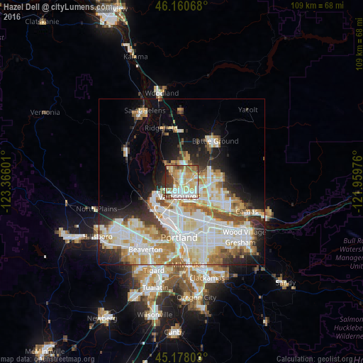
Analysis of Hazel Dell night lights 2016
Square area 10x10 km:
 18.18%
90-99
20.15%80-89
14.7%70-79
13.64%60-69
11.67%50-59
6.21%40-49
4.85%30-39
6.52%20-29
3.64%10-19
0.45%0-9
0%Square area 50x50 km:
10.23%90-99
10.68%80-89
4.97%70-79
4.85%60-69
4.22%50-59
3.09%40-49
2.89%30-39
2.73%20-29
5.53%10-19
8.27%0-9
42.53%Clear (daylight) street map image can be seen on geolist.org.
Map coordinates:
46° 9' 38.4" North, 123° 21' 57.6" West
45° 40' 17.4" North, 122° 39' 46.4" West
45° 10' 40.9" North, 121° 57' 35.1" West
Some cities around Hazel Dell sort by population:
• Vancouver
3.6 km =2.2 mi,  178°
178°
• Salmon Creek
4.5 km =2.8 mi,  13°
13°
• Five Corners
7 km =4.3 mi,  77°
77°
• Walnut Grove
5 km =3.1 mi,  94°
94°
• Minnehaha
1.8 km =1.1 mi,  141°
141°
• Felida
5.5 km =3.4 mi,  320°
320°
• Lake Shore
3 km =1.9 mi,  314°
314°
• Barberton
5.5 km =3.4 mi,  64°
64°
5796984 (p: 19,435)
Sources (retrieved 2019-11-25):
» Earth at Night: Flat Maps 2012, 2016