Olyphant night lights from space
Night Light of Olyphant (Pennsylvania) from space (United States) Src. Average luminocity for 10x10km area is 61.3333% and for 50x50km: 14.2902%.
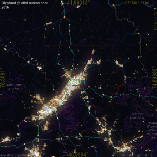
Analysis of Olyphant night lights 2016
Square area 10x10 km:
 11.9%
11.9%90-99
13.27%80-89
9.86%70-79
9.52%60-69
10.54%50-59
6.97%40-49
3.74%30-39
9.52%20-29
18.54%10-19
6.12%0-9
0%Square area 50x50 km:
2.17%90-99
2.28%80-89
1.66%70-79
1.97%60-69
2.1%50-59
2.48%40-49
1.77%30-39
2.3%20-29
4.16%10-19
6.8%0-9
72.31%Clear (daylight) street map image can be seen on geolist.org.
Map coordinates:
41° 59' 35.3" North, 76° 18' 22" West
41° 28' 6.3" North, 75° 36' 10.7" West
40° 56' 21.8" North, 74° 53' 59.5" West
Some cities around Olyphant sort by population:
• Scranton
8.4 km =5.2 mi,  218°
218°
• Dunmore
5.9 km =3.7 mi,  204°
204°
• Carbondale
14.4 km =8.9 mi,  35°
35°
• Old Forge
15.4 km =9.6 mi,  225°
225°
• Archbald
6.2 km =3.9 mi,  61°
61°
• Blakely
1.6 km =1 mi,  26°
26°
• Taylor
11.9 km =7.4 mi, 226°
• Dickson City
0.5 km =0.3 mi,  310°
310°
5204476 (p: 5,111)
Sources (retrieved 2019-11-25):
» Earth at Night: Flat Maps 2012, 2016