Dunmore night lights from space
Night Light of Dunmore (Pennsylvania) from space (United States) Src. Average luminocity for 10x10km area is 70.7483% and for 50x50km: 16.2789%.
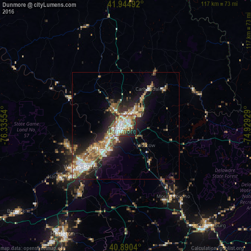
Analysis of Dunmore night lights 2016
Square area 10x10 km:
 19.73%
90-99
20.58%80-89
8.67%70-79
9.86%60-69
8.5%50-59
6.97%40-49
2.89%30-39
7.65%20-29
9.01%10-19
5.95%0-9
0.17%Square area 50x50 km:
2.52%90-99
2.68%80-89
1.84%70-79
2.1%60-69
2.52%50-59
2.8%40-49
2.04%30-39
2.49%20-29
4.91%10-19
7.52%0-9
68.58%Clear (daylight) street map image can be seen on geolist.org.
Map coordinates:
41° 56' 41.7" North, 76° 20' 7.9" West
41° 25' 11.3" North, 75° 37' 56.7" West
40° 53' 25.4" North, 74° 55' 45.4" West
Some cities around Dunmore sort by population:
• Scranton
3 km =1.9 mi,  246°
246°
• Old Forge
10.1 km =6.3 mi,  237°
237°
• Archbald
11.5 km =7.1 mi,  43°
43°
• Blakely
7.5 km =4.7 mi,  24°
24°
• Taylor
6.8 km =4.2 mi, 245°
• Dickson City
6.1 km =3.8 mi, 19°
• Moosic
11.5 km =7.1 mi,  230°
230°
• Olyphant
5.9 km =3.7 mi, 24°
5187542 (p: 13,379)
Sources (retrieved 2019-11-25):
» Earth at Night: Flat Maps 2012, 2016