New Brighton night lights from space
Night Light of New Brighton (Pennsylvania) from space (United States) Src. Average luminocity for 10x10km area is 46.1331% and for 50x50km: 23.2668%.
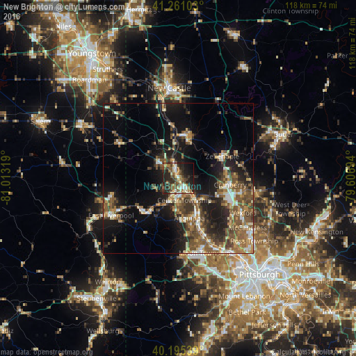
Analysis of New Brighton night lights 2016
Square area 10x10 km:
 3.41%
3.41%90-99
8.93%80-89
4.38%70-79
6.49%60-69
9.74%50-59
7.47%40-49
10.88%30-39
8.44%20-29
23.05%10-19
13.15%0-9
4.06%Square area 50x50 km:
1.93%90-99
3.24%80-89
2.55%70-79
2.69%60-69
3.63%50-59
5.6%40-49
5.5%30-39
3.67%20-29
6.76%10-19
14.75%0-9
49.69%Clear (daylight) street map image can be seen on geolist.org.
Map coordinates:
41° 15' 39.7" North, 81° 0' 47.5" West
40° 43' 49.2" North, 80° 18' 36.2" West
40° 11' 43.4" North, 79° 36' 25" West
Some cities around New Brighton sort by population:
• Cranberry Township
17.8 km =11.1 mi,  106°
106°
• Fernway
15.6 km =9.7 mi,  104°
104°
• Economy
16.2 km =10.1 mi,  153°
153°
• Aliquippa
12 km =7.5 mi, 150°
• Beaver Falls
2.5 km =1.6 mi,  342°
342°
• Ellwood City
14.7 km =9.1 mi,  7°
7°
• Ambridge
17.3 km =10.7 mi,  155°
155°
• Monaca
5.8 km =3.6 mi, 145°
5203116 (p: 5,891)
Sources (retrieved 2019-11-25):
» Earth at Night: Flat Maps 2012, 2016