Ellwood City night lights from space
Night Light of Ellwood City (Pennsylvania) from space (United States) Src. Average luminocity for 10x10km area is 25.9371% and for 50x50km: 18.9312%.
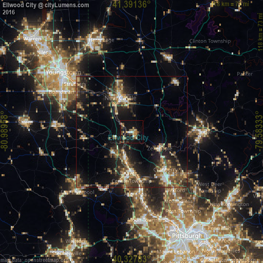
Analysis of Ellwood City night lights 2016
Square area 10x10 km:
 1.02%
1.02%90-99
3.06%80-89
4.93%70-79
2.38%60-69
4.42%50-59
4.25%40-49
5.61%30-39
2.55%20-29
5.27%10-19
31.97%0-9
34.52%Square area 50x50 km:
1.19%90-99
2.57%80-89
2.33%70-79
1.92%60-69
2.71%50-59
3.66%40-49
4.25%30-39
3.75%20-29
6.72%10-19
14.05%0-9
56.84%Clear (daylight) street map image can be seen on geolist.org.
Map coordinates:
41° 23' 28.9" North, 80° 59' 22.5" West
40° 51' 42.2" North, 80° 17' 11.2" West
40° 19' 40.2" North, 79° 34' 60" West
Some cities around Ellwood City sort by population:
• Cranberry Township
24.8 km =15.4 mi,  142°
142°
• New Castle
16.6 km =10.3 mi,  342°
342°
• Fernway
22.7 km =14.1 mi, 144°
• Economy
29.6 km =18.4 mi,  169°
169°
• Aliquippa
25.3 km =15.7 mi, 171°
• Beaver Falls
12.5 km =7.8 mi,  192°
192°
• New Brighton
14.7 km =9.1 mi, 187°
• Monaca
19.4 km =12.1 mi,  176°
176°
5188609 (p: 7,617)
Sources (retrieved 2019-11-25):
» Earth at Night: Flat Maps 2012, 2016